Design for the Delta: Students Propose Ideas for Floodplain Restoration
Field Trips Explore the Past and Present to Help Shape the Delta’s Future
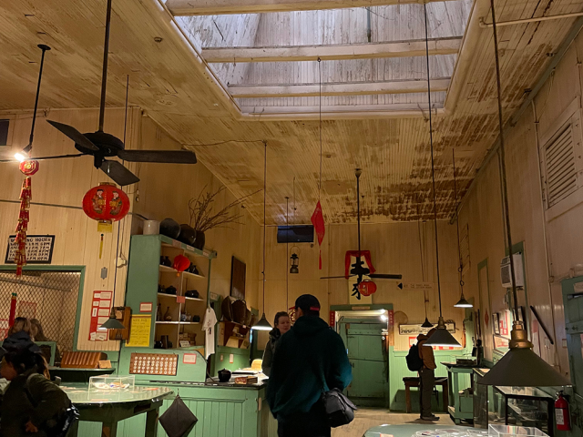
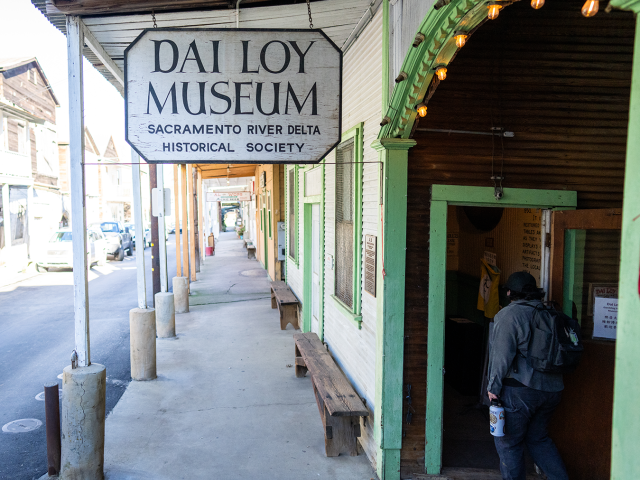
At the historic gambling hall named Dai Loy – which translates to "big welcome" – UC Davis landscape architecture students received just that, as they explored the rich history of Locke, a quaint town in the Delta. The landmark was one of the stops on a field trip that immersed students in the community's past, inspiring ideas for future improvements in the region that could benefit the town.
The students are part of LDA 170, a site planning and design studio course led by Professor Brett Milligan with the Department of Human Ecology. Milligan teaches students the technical, social and ecological aspects of designing real-world spaces and shows them how dynamic landscapes can be. The studio includes a service-learning component, giving students the opportunity to work with public agencies and communities on projects that can potentially be put to use.
“My goal in teaching this course is to help them refine skills in site interpretation and field work, as a basis for design premised on a strong understanding of the landscape,” Milligan said. “And looking at multiple ways of understanding the landscape as a complex, time-based medium, and how one works with that as a budding landscape architect.”
This winter, the course is focusing on the Sacramento-San Joaquin Delta, an ecologically and historically significant region that is prone to flooding and is involved in ongoing restoration efforts. Coursework includes going on site visits and conducting research exercises to create designs for the landscape that integrate environmental and community needs.
In January, students traveled about 40 miles southeast of Davis, with support from the Cynthia C. Lohr Experiential Learning Fund, for a walking tour through Locke. The small town was built in 1915 by Chinese immigrants. Clarence Chu, a longtime merchant there, led the group down the narrow Main Street, lined with century-old wooden buildings and vibrant displays of Chinese culture. It was designated a National Historic Landmark District in 1990 by the U.S. Department of the Interior, and what was once a school, boarding house and gambling hall, have been converted into museums that showcase Locke’s origins as a thriving Chinese community and the challenges it has faced over time.
“With Locke, it’s one of these unique historic communities that was built in a very vulnerable place,” Milligan explains. “We have so many places like this that are really vulnerable, particularly to floods or fires.”

Connecting with the natural landscape
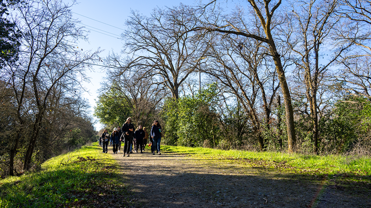
As part of their visit, students also walked six miles within the 500-acre Delta Meadows State Park located next to Locke and Walnut Grove. The park is open from dawn to dusk for walking along the levees and fishing in the adjacent sloughs but doesn’t currently have any visitor services, including restrooms, seating or trash bins. California State Parks is in the process of preparing a General Plan to lay out its goals and guidelines for the park’s future.
“Does the park seem bigger or smaller to you, based on what was on paper?” Milligan asked his students as they walked along a trail covered in leaves and crowded with tall oak trees. The park is home to river otters, wetland birds and other wildlife.
With sketchbooks in hand, students documented site details as speakers from the park district shared insights about planning efforts. Jacquelyne Escobedo, a landscape architecture major, sketched some drawings of what she saw throughout the day. She said going out into the field is an important step in the design process.
“I think it’s a really valuable experience because it helps contextualize the things that you’re looking at on maps and pictures,” Escobedo said. “It helps you better understand the space, and how it’s used, and how people perceive it, when you’re actually in it. You can’t truly get the 3D feel of an area if you’re constantly looking at it through pictures.”
Designing for a changing landscape
Milligan said students must design for a changing landscape, especially in this flood-prone area. Their challenge is to balance multiple benefits, including flood adaptation, ecological restoration and community needs and goals.

Historical research is a key component of the design process. Students examine maps and surveys from the early and mid-1900s, studying how the Delta’s habitats and waterways have changed over time. By looking at data from the past and making current observations, they gain insight into how previous land use decisions continue to shape the region today.
“There’s this rich, particular history that they’re trying to understand, like how this place evolved and why, and they’re trying to project forward through a design intervention to guide how it goes in the future,” Milligan said.
During the field trip, the group also did what Milligan calls ground truthing, comparing GIS data with on-the-ground details. Jose Mendoza, a landscape architecture major, found that walking around the town and the park, and hearing local stories, helped reshape his approach to his class assignment.
“In the beginning I was feeling a little bit lost as to what direction my classmate and I were going to go down for this project, but now I have so many ideas,” Mendoza said. “And there’s a story. I feel like it’s important to convey a story.”
Mendoza hopes the project is more than an academic exercise, and that it’s a chance to make a lasting impact in the community.
“I think it would be really fulfilling to see one or two ideas from my cohort actually get built out,” said Mendoza.
Just Transitions in the Delta
The students’ work in Locke is just the beginning. An upcoming field trip to the Cosumnes River Preserve and the McCormack-Williamson Tract in February will build on their findings in Locke, collectively forming a case study in how restoration efforts across different landscapes can enhance flood resilience and support habitat restoration.
The case study aligns with a broader initiative to develop and examine future adaptation scenarios for Delta communities called, Just Transitions in the Delta, a project funded by University of California's Multicampus Research Programs and Initiatives grant. Milligan serves as the project’s primary investigator and leads a team of interdisciplinary researchers who are working with community members and experts to examine how different water management choices in the Delta could impact people, wildlife and the economy as droughts intensify and sea levels rise.
“One of our scenarios is called ‘new green watershed,’ where there would be a lot of restoration, looking at what is the potential water and ecological benefits of upland restoration, better fire stewardship, floodplains, all of that, and what impact that would have on the Delta,” Milligan said.
Milligan said the team, working on the five-year project that began in 2023, is refining and modeling their six scenarios based on public feedback. They plan to hold more public workshops and ultimately an exhibition to present their findings.

Creating lasting change
As broader research efforts potentially shape the Delta's future, the students' fieldwork offers an important piece of the puzzle. By exploring the region's history, ecology and social needs, they can help inform decisionmakers on ways to transform this crucial landscape.
For Escobedo, she already recognizes the significance of the work her class is doing.
“The further that I get into the coursework at UC Davis, I realize that you are going to be a part of something bigger than yourself,” Escobedo said.
Media Resources
- Brett Milligan, Department of Human Ecology, [email protected]
- Tiffany Dobbyn, College of Agricultural and Environmental Sciences, [email protected]